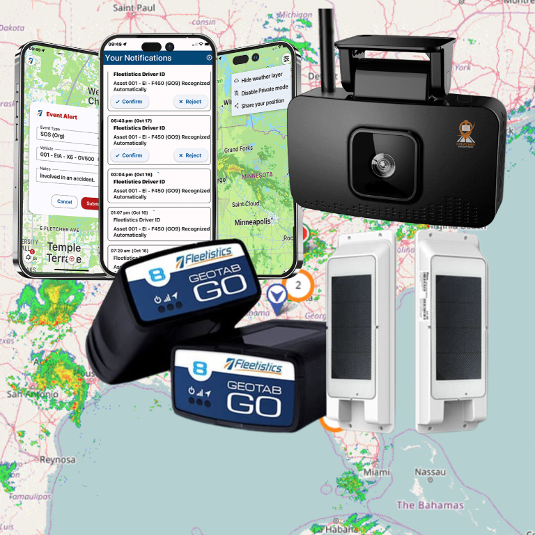

Knowing where a vehicle is matters most when the information can support a decision: reroute a technician, respond to an exception, confirm a delivery, or investigate an unexpected stop. A tracking system turns several separate steps into one operational view, but “real time” does not mean that every screen updates at the exact instant a vehicle moves.

So, how does real time vehicle tracking work? A device receives satellite signals to calculate position, collects selected vehicle data, and sends that information through a communications network to fleet software. The platform processes the incoming data, places vehicles on a map, and applies configured rules for alerts and reports. Update freshness depends on the device, network coverage, configuration, and platform processing.
Discuss your fleet tracking requirements with Fleetistics
The details become clearer when you separate location capture from data transmission and dashboard display. That distinction helps you evaluate hardware, installation methods, network conditions, and the governance practices that make tracking useful to both managers and employees.
How Does Real-Time Vehicle Tracking Work From Device to Dashboard?
Vehicle tracking is a chain of six connected layers. The device determines a position, sends that data over a communications network, and a fleet platform processes it before displaying the result on a map. The word real-time describes the intended flow, not a promise that every update is instantaneous or available at the same interval.
1. The receiver captures a position
GPS satellites broadcast signals containing their locations and precise time. A receiver in the tracking device measures when those signals arrive and calculates its distance from the satellites. Signals from at least four satellites allow the device to determine a three-dimensional position on Earth. GPS.gov explains the positioning process in more detail.
2. The device packages the reading
The tracker turns that position into a data record, often alongside a timestamp and other device-specific information. Depending on the selected configuration, the hardware may also collect vehicle or asset inputs. Fleet managers evaluating GPS tracking hardware should confirm which inputs, reporting settings, and power arrangements a particular device supports.
3. A network transmits the record
GPS determines where the vehicle is. It does not, by itself, send that location to your office. The tracker uses a cellular or another supported communications connection to transmit the record to the tracking platform. Coverage, device settings, and network availability can affect when the platform receives it.
4. The platform processes the data
The fleet platform receives the incoming record, associates it with the correct vehicle or asset, and applies configuration rules. It may translate coordinates into a usable place on a map, compare the location with geofences, or organize the information for later analysis.
5. The dashboard presents the current view
Users access the processed data through a web or mobile dashboard. The map view shows the latest received position and its timestamp, so a manager can distinguish a fresh update from an older one. The dashboard refreshes according to the device, network, platform, and account configuration rather than one universal cadence.
6. Alerts and reports turn records into action
Finally, the platform can use the records to support configured alerts, exceptions, route review, mileage analysis, or reports. That is where location data becomes operational context: a manager can investigate a missed stop, review asset movement, or evaluate a recurring route issue. The useful outcome depends on matching the device and software configuration to the fleet’s actual decisions.
What Does a Vehicle Tracking Device Actually Capture?
A vehicle tracking device starts with a location fix, then records information that helps explain where an asset is and what it is doing. The exact data set depends on the device, installation method, vehicle, and platform tier. That distinction matters when you compare systems: a basic location tracker and a broader telematics device do not necessarily collect the same inputs.
Location and time
The core input is usually a GPS position, recorded with a timestamp. A series of these location points can show movement, stops, route history. And the most recent reported position. “Real time” describes how quickly data becomes available for review, not a promise that every position is captured continuously or displayed instantaneously.
Vehicle and equipment inputs
Depending on the hardware, a device may also read ignition status, power state, mileage, engine information, diagnostic codes, or other vehicle signals. Some configurations connect through a diagnostic port, while others are installed inside the vehicle and may be hardwired to its power supply. Plug-in options can simplify installation, but the available data still depends on the device and the vehicle connection.
Additional inputs may support alerts or driver-behavior analysis, but these capabilities should be confirmed before purchase rather than assumed. Fleetistics offers tiered options spanning entry-level tracking through more comprehensive telematics and fleet-management platforms, so location, diagnostics, alerts, and behavior data can vary by selected configuration.
For practical planning considerations, review this GPS tracking deployment guidance. The goal is to match the device inputs to the decisions your team needs to make, not to collect every possible data point by default.
How Do Networks and Platforms Turn Pings Into Usable Data?
Once a tracking device determines a vehicle’s position, it packages that location with supporting details such as a timestamp. A communications connection then carries the report to the fleet platform. Cellular service is common, while other supported communication methods may fit specialized vehicles, equipment, or operating environments. The device, network, and platform each handle a different part of the process.
The timestamp matters because a map point without timing has limited operational value. The platform can use the reported time to place events in sequence. Distinguish a current report from an older one, and help managers review where a vehicle was during a particular period. The result is not necessarily an instantaneous view. Device configuration, network availability, reporting settings, and platform processing can affect when a point becomes visible.
What happens after the platform receives the report?
Fleet software stores and organizes incoming records so they can be viewed in a browser or mobile interface. Depending on the selected tier and device, processing may support map views, location history, reverse geocoding, exceptions, alerts, custom reports, or connections to other business systems. A platform might turn coordinates into a recognizable address, combine location with vehicle data, or make a filtered history available to an operations team.
Integration options extend that data beyond a single dashboard. APIs can let another application request tracking information, while streaming and webhooks can pass selected events into a dispatch, maintenance, safety, or customer-service workflow. These capabilities are configuration-dependent, so the right questions are which data the device produces, how frequently it reports, which interfaces are supported, and how timestamps are preserved.
Used well, the platform helps teams turn telematics data into decisions instead of merely watching dots move across a map. The practical value comes from connecting location records to the workflow that needs them.
How Do Maps, Alerts, and Reports Support Fleet Decisions?
A tracking platform becomes useful when it turns location records into an operational view. A map can show where vehicles or other connected assets were last reported, while route views help dispatchers compare actual movement with planned stops, service areas, and known constraints. The map is not the decision itself. It gives your team a shared starting point for deciding what needs attention.
Geofences add context to that map. A geofence is a virtual boundary around a location or area. Depending on the device, configuration, and platform tier, entering or leaving that boundary can trigger an exception alert. For example, an operations team might review an arrival at a customer site, a departure from a yard, or an unexpected movement outside an approved operating area. Each alert should have a defined owner and response so the system does not create noise without improving control.
Reports support decisions that do not require immediate intervention. Mileage summaries can help organize service planning, while maintenance notifications can help teams review an asset when it reaches a configured mileage or service condition. The available inputs and rules vary by vehicle, device, and selected platform, so confirm whether the system supports the specific mileage, diagnostic, or maintenance workflow you need.
Route workflows connect these views to daily execution. A dispatcher can use live GPS fleet tracking data to identify changing conditions, coordinate vehicles, and review whether routes are working as expected. Over time, recurring exceptions and report trends can point to practical changes in scheduling, maintenance timing, asset use, or service-area design.
Fleetistics can configure solutions with vehicle and asset tracking, exceptions, alerts, reporting, and integrations, depending on the selected tier. The strongest setup is the one that matches your decisions, data requirements, and response process rather than displaying every possible metric.
Why Is Real-Time Tracking Data Not Always Instant?
“Real time” describes a tracking workflow, not a guarantee that a map marker moves every second. A device first determines a position, then stores or transmits the reading, while the network and platform receive, process, and display it. Any delay in that chain can make the latest visible point older than the moment you open the dashboard. Geotab has developed an advanced algorithm to project where a vehicle is based on its previous location, speed, and heading, allowing you to visualize the movement of the vehicle on the map in real-time.
GPS accuracy also varies with the environment. Satellite geometry, signal blockage, atmospheric conditions, and receiver design all affect the position a device can calculate. Buildings, bridges, and trees may weaken or block signals. Indoor and underground locations can be especially difficult, while reflected signals from structures can create multipath errors that produce an anomalous position. See the NOAA GPS accuracy guidance and GPS.gov’s explanation of trilateration for the underlying mechanics.
Freshness depends on more than satellite visibility. A tracker may report differently when the vehicle is running, parked, or in a power-saving state. Device configuration, reporting settings, cellular coverage, network congestion, and platform processing can each affect when a reading arrives. Some systems may buffer data and transmit it after connectivity returns, so a later-arriving point is not necessarily a new position.
How should you evaluate a tracking timestamp?
Use a simple review sequence when a map point appears older than expected:
- Check whether the timestamp reflects device capture, network receipt, or dashboard refresh.
- Compare the reported time with ignition or movement state, signal conditions, and reporting settings.
- Review route history before judging the system from one stale-looking map point.
When comparing asset tracking connectivity options, ask how each device handles coverage gaps, sleep states, reporting intervals, and delayed uploads. The right configuration depends on whether your operation needs current movement visibility, historical route reconstruction, asset recovery, or a combination of those outcomes.
Which Installation Approach Fits Your Fleet?
The best installation approach depends on how an asset is used, who needs to access it, and what information the selected device can provide. A tracker may be installed inside a vehicle, connected through its diagnostic port, or deployed as a portable unit. These are configuration choices, not a universal ranking of better and worse options.
Vehicle and asset tracking installation tradeoffs
| Approach | Installation and power | Flexibility and tamper considerations | Data considerations |
|---|---|---|---|
| Hardwired | Professionally fitted and connected to the vehicle power supply. Installation generally requires more planning than a plug-in device. | Can support a less visible installation, but changing vehicles or servicing the unit may require additional labor. Physical access and device design still affect tamper exposure. | Available location, ignition, diagnostic, or other data depends on the specific hardware and configuration. Do not assume every hardwired device captures the same inputs. |
| Plug-in OBD | Connects through a compatible OBD or OBD-II port, which can simplify deployment and removal. Power comes through the vehicle connection. | Useful when devices need to move between vehicles, but the visible port and accessible device may increase tamper or accidental-disconnection exposure. | May provide vehicle information through the diagnostic connection, but supported data varies by vehicle, device, and platform tier. |
| Portable or asset-oriented | Designed for flexible placement on equipment, trailers, or other assets. Power may come from an internal battery or an asset-specific connection. | Supports changing deployment needs and non-vehicle assets, while placement, charging, battery life, and physical access become operating considerations. | Typically prioritizes location and movement visibility. Confirm reporting behavior, sensor inputs, and connectivity for the asset and use case. |
When comparing options, document the required power source, installation time, service process, expected tamper exposure, and the data your team actually needs. A fleet that changes vehicles frequently may value portability, while a permanently assigned service vehicle may justify a more involved installation. For mixed fleets, a modular approach can combine configurations rather than forcing every asset into one device type.
Also separate location tracking from vehicle diagnostics and driver-behavior information. The device and platform determine which signals are available, how often they are reported, and how they appear in the dashboard. Confirm those details before selecting hardware or promising a particular workflow.
How Should You Introduce Vehicle Tracking to Employees?
Employees are more likely to accept vehicle tracking when they understand its purpose, limits, and day-to-day impact. Introduce the program before devices are installed, explain how the system supports safety and operations, and give people a practical way to ask questions. Fleet managers can use this guide to introduce GPS tracking to employees and build buy-in through a clear, two-way conversation.
Explain what the system collects
Describe the information in plain language. Depending on the device and selected platform tier, this may include vehicle location, timestamps, mileage, diagnostics, or selected driver-behavior events. Be specific about what your configuration does and does not collect. Avoid presenting the system as a continuous, perfect record of every action. Device settings, network availability, reporting intervals, and platform processing can affect when information appears.
Set boundaries for tracking and access
State when tracking applies, such as during working time or while a company vehicle is assigned to business use, and address any exceptions that matter to your operation. Identify which roles can view live locations, reports, alerts, or historical records. Explain how information will be used, how long it will be retained, and which uses are outside the program’s purpose. Access should follow defined responsibilities rather than broad curiosity.
Put those expectations in writing. A written driver policy can document operating expectations, while a company driving policy can connect tracking practices to broader fleet procedures. Review the policies with supervisors so they apply consistently across teams.
Create an ongoing feedback channel
Give employees a named contact or shared channel for questions about alerts, location visibility, privacy, or incorrect records. Encourage managers to review concerns before rollout and after the first reporting cycle. Transparent notice is not a one-time announcement; it is an operating practice that helps the organization use vehicle data responsibly and preserve trust while improving fleet visibility.
Contact Fleetistics to evaluate a real-time tracking setup for your fleet
Frequently Asked Questions
How does a GPS tracker work in a car?
A GPS tracker receives signals from satellites to estimate the vehicle’s position and records that location with a timestamp. Depending on the device, it may also collect vehicle or asset data. The tracker then sends available information over a communications network to fleet software, where authorized users can view it on a map, configure alerts, and review reports.
How can you track a vehicle’s location online?
You need a tracking device installed or connected to the vehicle, a compatible communications connection, and access to the provider’s web or mobile platform. After the device transmits a location update, the platform processes it and displays the vehicle on a map. The age of the latest timestamp matters, because an online map does not guarantee that the location is instantaneous.
Why is real-time tracking data sometimes delayed?
Freshness depends on more than the GPS receiver. Satellite visibility, buildings, bridges, trees, vehicle power settings, device configuration, and network availability can affect when an update is captured or delivered. Review the timestamp and configured update behavior when evaluating data, rather than assuming that every map position represents the vehicle’s current second-by-second location.
How should employers introduce vehicle tracking to employees?
Explain what information is collected, when tracking occurs, who can access it, how it will be used, and how long it will be retained. Put those expectations in a written policy, give employees a way to ask questions, and apply access controls consistently. Clear notice and practical governance help employees understand the safety, service, and operational reasons for tracking.
Talk With Fleetistics About Real-Time Tracking
Your fleet may need a specific combination of devices, connectivity, platform features, and reporting. Discussing those requirements before deployment can help you compare practical options for your vehicles, assets, and operating policies. Contact Fleetistics to discuss your real-time tracking requirements and deployment options with the team.
Previous: How to Interpret Vehicle Diagnostic Codes in Fleet Operations | Next: Vehicle Maintenance Log Book App: What Fleet Managers Need.