Farm equipment rarely stays in one place or operates under predictable conditions. Tractors move between fields, implements may sit unpowered for weeks, and remote machinery can be difficult to locate when a job changes or an asset goes missing.
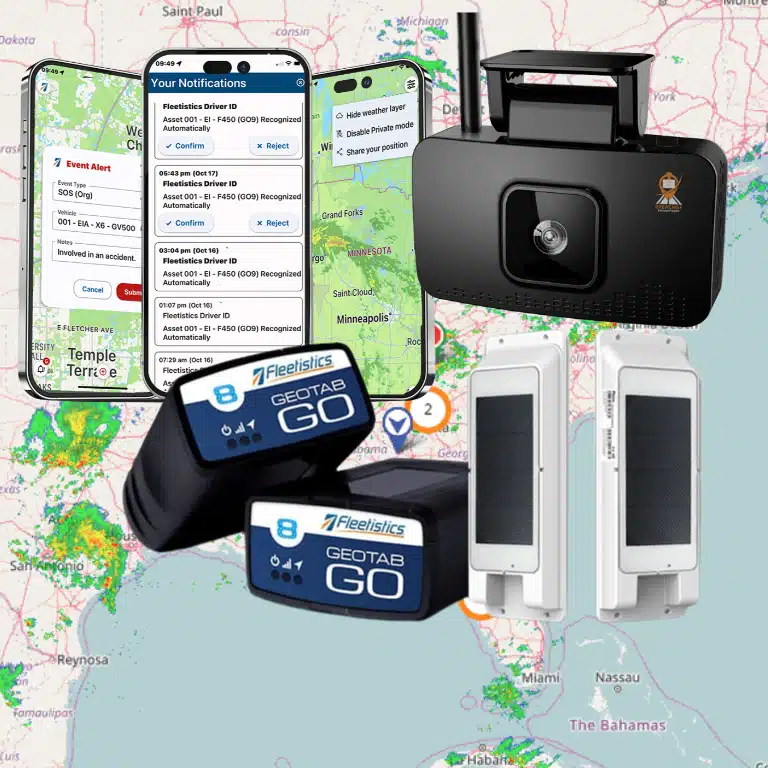
GPS tracking for tractors and farm equipment gives you a practical way to organize location history, field activity, utilization, and alerts across mixed agricultural assets. The right setup may combine vehicle telematics with hardwired, battery, solar, or other non-OBD trackers, depending on each asset’s power, connectivity, weather exposure, and data needs. GPS.gov also identifies applications including field mapping, tractor guidance, soil sampling, crop scouting, and yield mapping.
That broader view matters more than choosing a device by label alone. Start by examining why agricultural fleets need specialized tracking, then match visibility and alerting to the way your equipment actually works. Fleetistics can help you evaluate a modular approach through its fleet tracking by industry solutions.
Why Do Agricultural Fleets Need GPS Tracking for Tractors and Farm Equipment?
Agricultural operations rarely function from one central yard. Tractors may move between fields, implements may remain attached or staged separately, trailers may sit at a distant property, and seasonal equipment may spend weeks without operating. A vehicle-only tracking approach can leave important parts of that picture unaccounted for. Specialized GPS tracking helps you build visibility around the way your farm actually works, including the location, movement, and status of mixed equipment across large or remote properties.
The need is not simply to place a dot on a map. You may need to know whether a tractor reached the correct field, where an implement was last seen. Which assets are available for the next job, or whether equipment moved outside an expected operating area. Those decisions become harder when equipment is spread across multiple farms, yards, storage areas, and work sites. A system should therefore be evaluated around your asset mix and operating conditions, not selected solely because it works well in passenger vehicles.
Visibility across fields, yards, and properties
Farm work also changes with weather, crop conditions, and the season. GPS-based agricultural applications support planning, field mapping, soil sampling, tractor guidance, crop scouting, variable-rate applications, and yield mapping, according to the U.S. government’s GPS.gov guidance. GPS can also support work during rain, dust, fog, and darkness. Although the quality of the operational data you receive still depends on the device, installation, connectivity, and platform configuration. GPS.gov explains these agricultural applications in more detail.
That visibility can connect field activity with the broader operation. When GPS is combined with geographic information system data, operators can collect information with an accurate position and use it to analyze what is happening across the property. This creates a practical foundation for reviewing routes, coordinating people and equipment, and returning to specific locations when field work requires repeat visits.
Why powered and unpowered assets both matter
A specialized approach also accounts for more than tractors. Your operation may depend on trailers, tanks, attachments, generators, implements, and other equipment that has no standard vehicle diagnostic connection or does not run continuously. Some assets need a hardwired option, while others may be better suited to battery, solar, or another purpose-built tracker. Power availability, vibration, weather exposure, update frequency, and network coverage all affect the right choice.
Before selecting a system, inventory the assets you want to see and define the decisions that visibility should support. The goal is not a blanket promise to track everything under every condition. It is a workable combination of devices, connectivity, alerts, and reporting that closes the gaps between your fields, yards, properties, and equipment records.
Which GPS Tracker Fits Tractors and Farm Equipment?
The right device depends on the asset, not simply its name. A tractor that operates on public roads and has a compatible diagnostic connection may support a vehicle device. An implement, trailer, or stationary irrigation asset may need a different power source, enclosure, installation method, and reporting cadence. Before choosing hardware, document where the equipment operates, how often it moves, how frequently you need updates, and whether the asset has dependable power.
GPS tracker options for agricultural equipment
| Device type | Best fit | Advantages | Tradeoffs to evaluate |
|---|---|---|---|
| OBD-compatible vehicle device | Compatible trucks, support vehicles, and road-going equipment | Simple installation when the connection is available; useful for location, trip history, and vehicle telematics data. | Not every tractor or machine has a standard OBD connection. Compatibility, exposure to dust and vibration, and available vehicle data must be confirmed first. |
| Hardwired option | Powered tractors, sprayers, combines, and equipment with an accessible electrical system | Can provide a secured installation and continuous power while the asset is operating or connected to its battery. | Installation takes more planning. Battery behavior, service access, wiring protection, and the effect of power disconnects should be reviewed with the installer. |
| Battery or solar asset tracker | Trailers, implements, containers, and stationary or infrequently powered equipment | Supports assets without a convenient vehicle connection and can simplify deployment across mixed, unpowered inventory. | Battery life and update frequency depend on configuration, movement, weather, sunlight, and connectivity. Confirm how the unit will be protected and serviced. |
| Satellite-capable option | Remote equipment that regularly operates beyond dependable mobile coverage | Can extend communication options for isolated fields, remote staging areas, and other locations where cellular coverage is limited. | Review coverage, message frequency, antenna placement, environmental durability, and operating costs. Satellite capability does not remove the need for a suitable installation and service plan. |
Match the tracker to the power and environment
Powered machinery often benefits from a device installed with its electrical system, but hardwired options are a configuration choice rather than an automatic upgrade. The practical question is whether the installation remains reliable through vibration, dust, moisture, seasonal storage, maintenance, and battery isolation. For an implement that sits disconnected from a tractor, a battery or solar design may be more appropriate than a vehicle-oriented device.
For remote farms, connectivity deserves equal attention. Mobile coverage may be sufficient across some fields but unreliable at distant properties or during transport between work areas. A satellite-capable option may help in those conditions, although the required reporting interval and service coverage should be validated before purchase. If a device cannot communicate consistently, the platform cannot provide the visibility your team expects.
Choose data that supports the decision
Do not select hardware by feature list alone. Decide whether you need last-known location, movement alerts, utilization information, maintenance inputs, or more frequent operational updates. Fleetistics supports multiple device types and IoT-ready solutions for equipment without a standard OBD connection. Its specialty equipment tracking resources can help you compare non-standard installations, while the GPS tracking hardware overview provides a starting point for matching hardware to your asset mix.
A practical rollout may combine vehicle devices for compatible support trucks and hardwired units for powered machinery. Battery, solar, or satellite-capable trackers may suit non-powered and remote assets. That modular approach gives you useful coverage without forcing every tractor, trailer, and implement into the same device category.
How Can Field Boundaries and Geofences Improve Farm Operations?
Field boundaries turn a large, dispersed operation into a set of locations your team can manage consistently. A geofence is a virtual boundary drawn around a field, yard, storage area, access road, or other property. When a tracked asset enters or leaves that boundary, the platform can record the movement and, when configured and supported by the device connection, send an alert.
Map fields, roads, and recurring work areas
Start with a reliable map of the places your equipment actually operates. GPS receivers can collect location information for mapping field boundaries, roads, irrigation systems, and crop problem areas. The accuracy of GPS also supports maps with acreage, road locations, and distances between points of interest. These maps give dispatchers and farm managers a shared reference for deciding where a tractor should be. Which access route makes sense, or where an implement was last used.
This is more useful than a single live dot on a screen. You can organize boundaries around working fields, equipment yards, fuel areas, barns, and temporary staging locations. A boundary can help distinguish normal movement within a property from movement that needs review. The right design depends on the size of the property, how close neighboring fields are, and whether the device reports often enough for the intended use.
Repeat navigation and fieldwork with less guesswork
GPS can help operators navigate repeatedly to specific field locations year after year for soil sampling or crop monitoring. That repeatability supports a more consistent process when a team needs to revisit a drainage issue, irrigation point, crop problem area, or sampling location. GPS.gov also identifies field mapping, tractor guidance, crop scouting, variable-rate applications, and yield mapping as agricultural uses of GPS: GPS precision agriculture guidance.
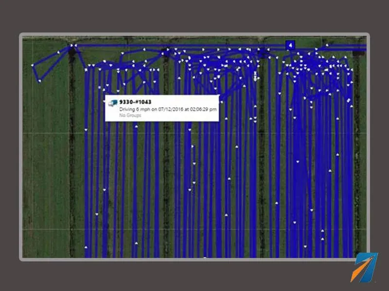
Accurate field navigation can also reduce skipped areas and redundant applications by helping operators follow established paths. It does not replace agronomic decisions or guarantee a particular application result. Instead, it provides position information that can be combined with farm maps, operating procedures, and the equipment data available from the selected device.
Use movement alerts as an operational signal
Geofences can support practical alerts, such as movement out of a storage yard after hours, entry into a restricted area, or arrival at a worksite. Managers can then review the asset’s location history and determine whether the movement was scheduled, authorized, or worth investigating. Automatic vehicle location can provide a useful foundation for that map visibility and location-history workflow.
Remote farms require realistic expectations. Cellular coverage may be weak or unavailable in some fields. A device may also have limitations related to power, installation, weather, terrain, reporting frequency, or configuration. An alert cannot be guaranteed when the tracker cannot communicate with the platform. Before relying on geofences for security or dispatch, test the device in the areas where it will operate. Define the event that should trigger an alert, and confirm how delayed or unavailable data is handled.
What Can Utilization Data Tell You About Farm Equipment?
Location data becomes more useful when it shows how equipment is being used, not only where it is parked. For tractors and farm equipment, utilization reporting can connect operating activity and engine-hour context with dispatch, maintenance, and replacement decisions. That gives you a clearer view of which machines are supporting daily work, which are sitting idle, and where your operation may have scheduling gaps.
Measure activity in terms your operation can use
Start by defining what utilization means for each asset. Depending on the equipment and the available device data, useful measures may include engine hours, movement history. Time in a defined field or work area, activity by day, and the number of assignments completed. A tractor that moved several miles may not have completed productive fieldwork, while a stationary implement may be valuable even when it produces little location movement. The right metric depends on how each asset contributes to the operation.
Engine-hour context can help separate time spent operating from time spent parked or awaiting dispatch. It can also help you compare similar machines under similar conditions without assuming that every tractor reports the same data. Device selection, installation, power source, connectivity, and equipment type all affect what the platform can reliably show.
Use utilization data to improve dispatch
When managers can view equipment on a map, review reports, and access activity history, dispatch decisions become less dependent on memory or phone calls. You can see which tractor or implement is already near a field, identify equipment that is available for the next assignment, and reduce unnecessary movement between work areas. In a large or distributed operation, this visibility can also make it easier to coordinate support vehicles and equipment transfers.
Useful dispatch questions include: Which assets are currently active? Which are available but underused? How long has a machine been waiting between assignments? Are two teams being sent for work that one properly equipped machine could handle? Tracking will not answer every operational question by itself, but it gives you a consistent activity record for reviewing the answers.
Identify underused equipment and plan maintenance
Utilization analysis can identify underused equipment and inform fleet-right-sizing decisions. Before purchasing another machine, you can compare available capacity with actual activity across the equipment you already own or lease. That does not mean automatically selling an idle asset. Seasonal demand, backup requirements, crop timing, and reliability all matter. It does mean that replacement and purchasing discussions can start with evidence.
Maintenance planning benefits from the same discipline. Engine-hour or activity records can help schedule service around actual use instead of relying only on calendar reminders. Combine those records with maintenance history, alerts, and equipment condition data where available. Fleetistics supports reports, maintenance scheduling, dispatch, map visibility, and integrations within its broader fleet management capabilities, allowing you to build a review process around the metrics that matter to your farm.
A practical utilization dashboard should track active hours, idle or inactive periods, assignment status, location by work area, maintenance due status, and recurring dispatch delays. Review those measures by asset type and season. The goal is not to collect every possible data point. It is to turn equipment activity into decisions about scheduling, service, capacity, and future investment.
Can GPS Tracking Help Protect Farm Equipment From Theft?
Yes, but GPS tracking is a prevention and response tool, not a guarantee that stolen equipment will be recovered. Tractors, sprayers, trailers, and other high-value assets left in remote fields or staging areas can be vulnerable to unauthorized movement, fuel siphoning, or tampering. The practical goal is to know what you own, where it was last reported, what changed, and who should respond.
Start with an accurate equipment inventory
Before configuring alerts, document each tractor and implement in the tracking platform. Record the asset name, serial or unit identifier, normal operating area, assigned location, device type, and the people responsible for reviewing alerts. This inventory gives your team a clear baseline. It also helps you distinguish an authorized move to another field from an unexpected departure.
For trailers, stationary equipment, and implements without a standard vehicle connection, ask about non-vehicle asset tracking. Device selection should match the asset’s power access, installation conditions, weather exposure, vibration, connectivity, and desired update frequency.
Use location history and configured alerts together
A last-known location can narrow the search when an asset is misplaced, moved unexpectedly, or no longer visible to an operator. Location history can also show when the equipment was last active and the route or area it occupied, subject to the device’s connectivity and reporting settings.
Configure movement alerts for equipment that should remain parked during defined periods. A curfew alert, for example, can notify an authorized manager when a tractor moves overnight or outside an approved work window. You can also configure alerts around a farm, yard, storage lot, or field boundary. These virtual boundaries are commonly called geofences. When an asset enters or leaves one, the platform can generate an alert if the rule, device, and connection support that event.
Keep alert rules specific. A notification for every normal field-to-field move will quickly become noise. Start with high-value assets, overnight windows, storage areas, and unusual movement patterns. Then adjust the rules after reviewing real operating behavior.
Define the response before an alert arrives
An alert is useful only when someone knows what to do next. Establish an escalation workflow that identifies the reviewer, confirms whether the movement was authorized. Checks the asset’s last reported location, contacts the operator or site manager, and notifies law enforcement or an insurer when appropriate. Preserve location history and related records rather than relying on memory.
Coverage gaps, drained batteries, damaged devices, poor installation, and delayed reporting can limit visibility. GPS tracking cannot prevent every theft, locate an asset that is not reporting, or replace physical security. Pair configured alerts with locks, lighting, access controls, documented policies, and regular device checks. Fleetistics provides equipment tracking and asset-protection services, but the right configuration depends on the equipment and operating environment.
What Should You Evaluate Before Choosing a Farm Equipment Tracking System?
The right system starts with the equipment and the work environment, not with a preferred device. Before you compare platforms, document which assets need visibility, where they operate, how often their locations must update, and what decisions the data should support. A tractor working near a farm office may have different requirements from an implement stored in a remote field or a trailer that sits idle for weeks.
Will the system work where your equipment operates?
Ask how each device handles weak or intermittent connectivity. Remote agricultural locations may require different mobile-network options, satellite capability, or local data handling than equipment operating near reliable coverage. Confirm what happens when a device temporarily loses service: Does it retain location history and forward it later, or does the platform simply show the last reported position? Treat “real time” as a configuration and coverage question, not a universal promise.
Also evaluate the update frequency you actually need. Frequent updates may be useful during active fieldwork or when investigating unexpected movement. Less frequent reporting may be appropriate for a stationary implement where battery life matters more than minute-by-minute visibility. Make the reporting interval part of the use case and pilot rather than accepting a default setting.
Does the installation match each asset?
Do not assume every tractor or machine has a standard OBD connection. Road vehicles may support plug-in hardware, while tractors, implements, trailers, and stationary equipment may need J1708, J1939, hardwired, battery-powered, solar, or other non-OBD options. Compare installation time, access to a dependable power source, battery maintenance, tamper considerations, and whether the device can be serviced without disrupting seasonal work. Fleetistics supports multiple device types and IoT-ready solutions for assets without standard OBD connections, but the appropriate choice still depends on the specific asset.
Can the hardware withstand farm conditions?
Review the device’s suitability for vibration, dust, moisture, temperature changes, washdown, and long periods outdoors. Ask what “rugged” means in the proposed configuration and which environmental limits are documented. Confirm that the installation location will not block service access or expose the device to avoidable damage. A device that performs well in a road vehicle may not be the right fit for an implement, off-road machine, or exposed support asset.
Will the data lead to useful decisions?
Define the reports and alerts before you buy. Useful questions might include: Which equipment is active, underused, or overdue for maintenance? Which assets entered or left a configured property boundary? Can managers review location history, activity, maintenance schedules, and utilization in one workflow? Fleetistics identifies equipment utilization, off-road tracking, rugged devices, and PTO monitoring as relevant heavy-equipment needs. Its platform also supports map visibility, alerts, custom reports, maintenance scheduling, dispatch, APIs, and partner integrations.
How will you govern the rollout?
If equipment is assigned to employees or operators, provide transparent notice and explain what is collected. Why it is collected, who can access it, and how long records are retained. Establish clear policies and an escalation process for alerts. Operator buy-in is more durable when tracking is presented as an operational and safety tool rather than covert surveillance.
Can you validate the system with a measured pilot?
Choose a representative sample: different asset types, power configurations, operating areas, and coverage conditions. Set baseline measures such as location-report reliability, installation effort, alert usefulness, maintenance workflow, and time spent finding equipment. Review the results with operators and managers, then adjust devices, reporting intervals, and policies before expanding. A measured pilot gives you evidence about fit without assuming that one configuration will work equally well across the entire farm.
How Can Fleetistics Support Agricultural Fleet Tracking?
Choosing a tracking platform for tractors and farm equipment is not only a hardware decision. You need a practical way to match each asset with the right device, connectivity option, reporting level, and operating workflow. Fleetistics approaches agricultural fleet tracking as a configuration and implementation project, not a one-size-fits-all product sale.
As a Geotab reseller, Fleetistics helps you evaluate how Geotab-powered technology and other suitable devices can fit your operation. Fleetistics remains your advocate and implementation partner. The team can help you determine which assets need vehicle telematics, which require non-OBD asset tracking. And how location data should support dispatch, maintenance, utilization, security, or inventory decisions. That distinction matters on a farm, where tractors, trailers, implements, and stationary equipment may have different power, connectivity, and data requirements.
The solution can be modular. You might begin with last-location visibility and an asset inventory for equipment that is rarely moved, then add broader vehicle and asset tracking as your operational needs develop. For active equipment, the platform can support map visibility, configured alerts, reports, maintenance scheduling, dispatch, APIs, and integrations. Fleetistics also identifies off-road tracking, rugged devices, equipment utilization, and PTO monitoring as relevant considerations for heavy-equipment operations. Your implementation should focus on the decisions you need to make, rather than collecting data that no one will use.
Fleetistics has served fleets since 2001 and supports businesses operating vehicles, equipment, and watercraft across the USA, Canada, and Mexico. That experience can be useful when your agricultural fleet spans multiple locations or includes a mix of powered and unpowered assets. It also gives you a structured starting point for comparing installation choices, data needs, and future expansion.
A practical next step is the exact 30-day Solution Evaluation Process. Use that period to validate device performance, connectivity, alert configuration, reporting, and user adoption against real farm workflows. You can test whether the proposed setup provides useful visibility before committing to a broader rollout.
Contact Fleetistics to discuss your equipment mix, operating conditions, and the agricultural tracking approach that fits your fleet.
Frequently Asked Questions
Can you track a tractor without an OBD connection?
Yes. Tractors, implements, trailers, and stationary equipment may need hardwired, battery, solar, or other non-OBD asset trackers. The right choice depends on available power, installation conditions, durability, connectivity, update frequency, and the data you need. Fleetistics supports multiple device types and IoT-ready solutions for equipment without a standard OBD connection.
Can GPS tracking map farm fields and boundaries?
Yes. GPS receivers can help map field boundaries, roads, irrigation systems, and crop problem areas, while accurate positioning supports farm maps with acreage and distances between points. You can also use location data to return to specific areas for soil sampling or crop monitoring. See the U.S. government guidance on GPS and precision agriculture.
Will farm equipment tracking work in remote areas?
It depends on the available connectivity and the tracker selected. Mobile coverage may be sufficient in some fields, while especially remote locations may require a satellite-capable option. Confirm coverage, data transmission, local storage, and reporting behavior before deploying equipment across rural or low-coverage areas.
Can GPS tracking alert me when a tractor moves unexpectedly?
A configured geofence or movement rule can alert you when an asset enters or leaves a defined area or moves during a restricted period. Alerts support a response workflow, but they do not guarantee theft prevention or recovery. Set boundaries, recipients, escalation steps, and operator policies around the way your farm actually operates.
How can tracking data improve equipment utilization?
Tracking can combine location, activity, and available engine or equipment data with reports and maintenance planning. That helps you identify underused equipment, plan service, coordinate dispatch, and make more informed right-sizing decisions. Review utilization by asset and season rather than relying on a single fleet-wide average.
Ready to Evaluate GPS Tracking for Your Farm Equipment?
A consultative review can help you match tracking options to your tractors, implements, trailers. And other equipment, while accounting for power, connectivity, durability, and the data your team needs. Contact Fleetistics to discuss a practical evaluation for your operation and identify an approach that fits your equipment mix.