
Seamlessly Connect Your Fleet Data with Any System
Unlock smarter operations with Fleetistics’ flexible APIs. Integrate GPS data, telematics, dashcams, ELD, and more into your existing workflows.

Why Integrate with Fleetistics?
Your fleet generates a massive amount of valuable data—from vehicle location and speed to maintenance alerts and driver behavior. Fleetistics gives you the tools to integrate this data into the software platforms you already use, so your entire organization runs more efficiently.
Consolidate multiple data sets for ai interpretation
Enhance decision-making with real-time data
Automate alerts, reports, and compliance checks
Connect with ERPs, CRMs, dispatch, and analytics tools
Data Integration and Mapping Services
Fleetistics provides alternatives to expensive Google mapping and reverse geo-coding services. There are many applications for the data being collected by GPS tracking and telematics devices. The more ways the GPS data is utilized, the larger the return on investment. Fleetistics supports and encourages fleet managers to utilize the data by providing a wide range of data options.
Device Controller Service
Bring your own IoT device and Fleetistics will process the data and insert it into a GPS platform or forward the data through an API without providing a web application or service interface. This service is for companies that have the skills to work with the data once it is received but do not have the expertise for the complex process of integrating raw data and getting it into a database with a service controller.
Mapping
Fleetistics provides a mapping service as a mid-range service between public OpenStreetMaps.org and expensive Google maps. Fleetistics maintains a private OSM hosting solution that provides much faster and more reliable maps than the free public OSM service. Essentially with the Fleetistics mapping service customers get about a 50% reduction in cost for Google map subscription services.
Reverse Geo-coding
RGC is simply an address lookup service. This service is generally purchased in conjunction with a mapping service. A company may use this with other mapping needs.
Fleet API Overview
Our Fleet Data API offers a REST-based interface to pull real-time and historical fleet data from your GPS tracking system. Use it to integrate location, status, events, and more into your preferred software environment.
Software Development Kit
For users of our premiere GO System, an SDK (software development kit) is available to simplify the development of custom data integrations. This SDK provides working code samples for the common functions available through the API. These code samples are available for Javascript/HTML and ASP.net.
APIs are also available for free with this high-end system.
Application Programming Interface (APIs)
Through the use of our APIs, users are provided access to the power of real-time data availability. Data can be securely retrieved from Fleetistics by a customer and used in other system. Importing location information is a very popular integration and there are literally hundreds of custom integrations done today.
Fleetistics offers a complete suite of integration related services from APIs to mapping to help customers get more from the data already being collected. Custom data solutions and integrations with IoT data is available. APIs can be written as part of custom project for unique requirements.
Fleet SDK Overview
With Fleetistics, developers quickly build custom applications and integrations. It includes code samples, libraries, and detailed documentation to accelerate your projects.
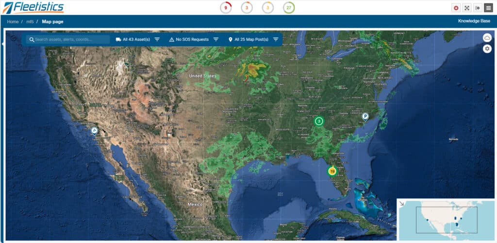
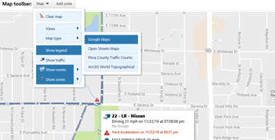
Map Development
Customers that have a custom solution and need maps can get maps from Fleetistics as an alternative to expensive Google maps. Fleetistics utilizes OSM maps but on a private server. Public OSM maps are free but often slow and not suitable for a business production environment.
Fleetistics OSM maps are stored and managed on Fleetistics servers. The number of connections and users is controlled and limited based on system resources. Map tile rendering is extremely fast and consistent. Resources are managed to provide customers the best possible experience. Although very fast, satellite images are not available.
Why Use OSM?
OSM is a mature platform that is created and maintained by users globally. Metropolitan areas are very well mapped and accurate. When a new road is added or a correction is needed you can submit the change to the OSM community and the mapping database will be updated in a few weeks. Use this link to see OSM maps in action.
Reverse Geocoding
Reverse geocoding is a fancy name for address lookup. This is accomplished by submitting a GPS coordinate and getting an address in return. This service can be very expensive but is critical to making sense of the GPS data collected. Fleetistics has invested in technology that enables fleet customers to reverse geocode from our data set for a fraction of the cost of a service such as Google.
BYOD GPS Data Processing
Some fleet operators want to build their own GPS tracking system. Although we do not recommend it due to cost, time and expertise needed; Fleetistics does offer a data processing service (DPS).
GPS trackers transmit a complex code that represents all types of data. It is not code that looks like lat/long or other formats you would recognize, but rather a complex series of numbers and values that represent longer strings of data. Translating what is basically machine code to a useful format is a special skill and very difficult.
Fleetistics has the skills and environment to decode the data and forward it to customers through an API for a small monthly service fee to accomplish custom data integration. Our team has invested in the skills and infrastructure to provide a reliable, efficient and cost effective GPS data decoding and forwarding service to anywhere on the globe.
Multi-Source Data Integration
Integration of data from multiple sources is a requirement many organizations are facing today. The information or data collected from GPS systems can be utilized by other systems to provide a more complete picture of vehicle and driver operations and performance. The convergence of data from these multiple systems are accomplished through an API (application programming interfaces) or an SDK. Fleetistics offers APIs for all three of our GPS products.

How It Works: Step-by-Step Integration
Getting started with our API & SDK is simple. Here’s how you’ll go from access to automation:.

Request API Key or SDK package
Review documentation & code samples
Connect to the test environment
Build your integration
Move to live deployment
Monitor and scale as needed
Start Your Integration Project
Let’s connect your systems and transform your fleet data into a strategic asset. Whether you’re integrating into a single app or an enterprise platform, our team is here to support you..

Custom Integration Examples
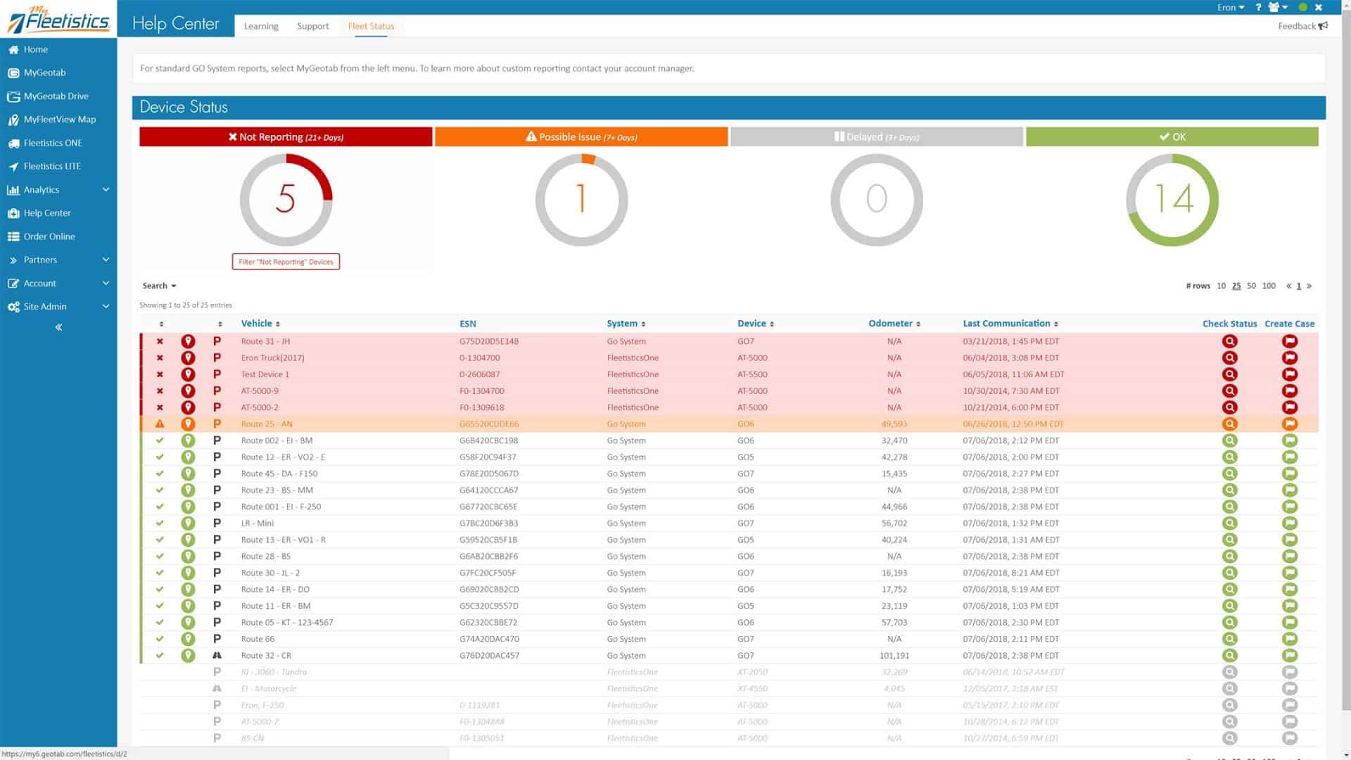
Device Status Table Integrated with Geotab and Fleetistics Support Ticketing System